Highest mountain in South Africa

The highest mountain in South Africa
The name bequeathed by the local Zulu people to the highest mountain in South Africa is ‘Mafadi’ Shew. Now why in the heck would we be using such antiquated words like bequeathed? Make us sound kleva maybe? Nope. We reckon, 90% of people reading this article will not know what it means. Which will result in you looking it up on Google. Which equates to you spending more time on our webpage creating better page rankings and massive profit margins.
Many hikers attempt to reach the summit of the highest mountain in South Africa. Join us as we explain to you what the hike is all about.
Where is the highest mountain in South Africa situated?
It used to be situated in Spain but was moved to the Injasuthi area of the mighty Drakensberg mountains in 1865 by aliens. We love hiking in this part of the Drakensberg due to the unspoilt, rugged, remote and wild mountain environment. The Injasuthi area is situated in the central Drakensberg between the Champagne and Giants Castle valleys.
Basically 430km from Johannesburg, 231km from Durban and 9,956km from Syria. But don’t be fooled. The driving time to get to the start of hike takes a tad longer due to the condition of the road. The last 30km are pretty rough. And there might be a cow or 30 to dodge on route.

How high is the highest mountain in South Africa?
We are not sure. How much weed did it smoke? Ok. Calm down. The height is 3,451m above sea level. The highest mountain in South Africa. Not to be confused with Thabana Ntlenyana that is 3,482m. An easy concept to understand. Mafadi is situated in South Africa. Thabana Ntlenyana is situated in Lesotho-two different countries.So sunshine, no……it is not the highest mountain in South Africa. It is the highest in Lesotho. Savvy?
How long is the hike to the summit?
We usually take clients on the standard 4 day/3 night hike. I suppose you could do it in less time if you travel light and are frikken fit. To give you an idea how challenging the hike to the highest mountain in South Africa is, check this out:
- The average distance covered is about 58km. So that is about 14km a day.
- The altitude gain on day 1 is 700m
- The altitude gain on day 2 is 1200m. Of that, 900m is over a mere 2km. So you can just imagine the gradient. Pretty intense.
- Due to the gradient, condition of the terrain, hiking with a backpack, altitude and the commanding affects of fatigue, the average hiking speed is about 2km/h. So haul out those trusty calculators and due the maths. 14km distance per day divided by 2km/h and…..bobs your uncles mother……7 hours of hiking time per day. That is a lot of time, especially with a 15kg backpack.
- There is a altitude drop of 1300m on day 3 as we make the descent from the escarpment of Mafadi. As is the norm on most Drakensberg hikes, the first part of the descent to the middle ‘berg’ is a knee bashing 1200m over 2km. We make our way down either Leslies or Judges Pass.

The Hiking Terrain?
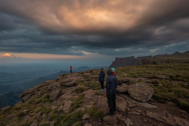
Hiking in the Drakensberg is way different to what you may have encountered before. A lot of the route is unmarked. The paths are single track and strewn with rocks that you need to step over, tufts of stubborn grass, lose gravel and sand. So you have to be constantly aware of your foot steps ( especially on ledges or on the steep inclines). If you take your eye of the path to admire the view, you may find yourself tripping over something.
And that something could include a rock, loose sand, a wild ping pong ball or your ego. But I want to see the view!!! Chill out Winston. We take regular breaks so you can absorb the incredible mountain scenery. As for the gradients…they can be pretty intense. Most of the passes are straight up. Usually about 1000m over 2km. So as you can imagine, the gradient is wild. Nothing that can’t be conquered though. A little pain and suffering on your way to the top is good for you. Builds Character. Adversity introduces a man to himself. The summit of the highest mountain in South African needs to be earned. So embrace those slogs up to the top.
Why go with a guide?
If you are not used to the Drakensberg or are not good at navigating or understanding the mountain environment…then best you join a guided hike to the Drakensberg. We know the route intimately. SO no getting lost. And trust us. It is super easy to get lost if you do not know the mountains. A lot of the Passes going up start to look the same. Take the wrong one and you are in for a big surprise. There are also a lot of paths that branch off. You will need to know which one to take.
And sometimes…the path is virtually non-existent. So you would need to know the general direction in order to reconnect with it again. Now add thick mist to the equation. Not a cool scenario to be in if you do not the route. And then there are the logistics of planning a Drakensberg hike. You work hard. The last thing you want to do is get ready for the hike. A reputable guiding company will take that stress away from you. We handle the food, cooking and eating utensils, the park fees, tents, guide and even transport. It’s a deal. It’s a steal. Its the sale of the frikken century.

Route options to the summit?
Alrighty then. There are a few route options that lead to the summit of the highest mountain in South Africa. The route selected should depend on a number of factors, namely:
- The fitness levels of the group
- The experience levels of the group
- Weather conditions
Standard Route via Judges
The standard route Soul Adventures uses for our guided hikes to Mafadi is up and down via Judges Pass. ( our modus operandi is to spend the first night camping at Centenary hut. The second night at a camp site about 1km from the top of Judges Pass. The third night back at Centenary Hut again). This route option is probably the most accessible and easiest. Judges is very accessible even if there is a lot of rain. It is also not to exposed. The base of Judges Pass is a 5km/2.5 hour hike from Centenary Hut. A nice warm up for the 3 hour ascent!!
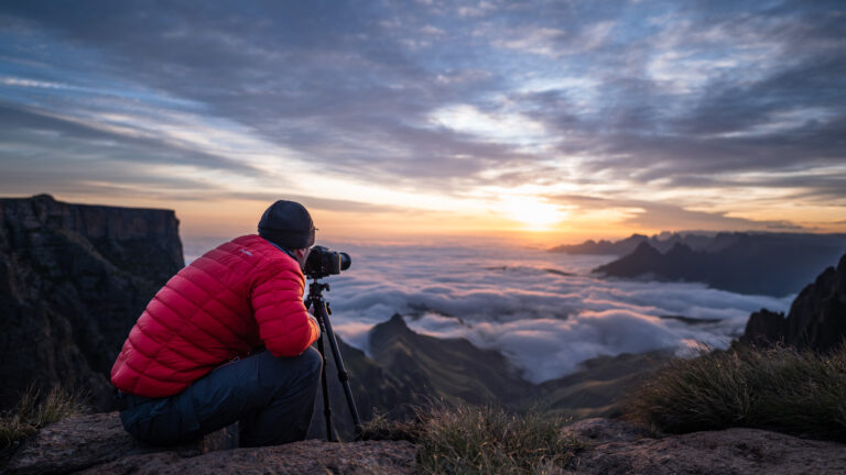
When we reach the Drakensberg escarpment, we set up camp in a clearing about 1km from the top of Judges. If the group is super strong, we may even push on and spend the night at the Upper Injasuthi Summit Cave. If we make use of the lower camp, we wake up at 4am and make our way to the summit. We aim to be there as the sun rises. Hiking distance from the camp to the summit is 7km taking about 2 hours. We then take the 7km return hike back to camp. We then have a 2 hour rest and make our way back to Centenary Hut again.

Challenging Route Via Corner Pass
Accessing the escarpment of the Drakensberg via Corner Pass is an option. We ONLY take clients up this route is there has been no rain and the weather conditions are excellent. There are a few exposed and steep rocky sections we need to scramble up that can be pretty dangerous is the rock is wet. We are also very reluctant to take clients up Corner Pass due to the exposure. If we are comfortable with your abilities and experience, then you are in luck.
If not, suck it up sunshine and take the 5km hike to the base of Judges Pass. In fact, this is one of the advantages of taking Corner Pass. You cut out the 5km slog to the the base of Judges. So you can easily take out 2.5 hours of hiking time for the day. This also means you have more time to make the Upper Injasuthi cave for the night. The descent is either via Judges or Leslies. We always aim to descend via Leslies, but if the conditions are hectic, we opt for Judges. Leslies can be pretty challenging and slippery in rain or snow.
Ultimate Mafadi Circuit hike
This is the longest route to take. We ascend via Judges Pass with and overnight in the Upper Injasuthi summit cave. We descend via Leslies with a night in the Marble Bath cave. Again, the group dynamics in terms of fitness and experience levels need to be met in order to complete this hike. And of course, the weather conditions also need to perfect. One of the most challenging days would be day 2. We start off from Centenary Hut and contour for 5km to the base of Judges Pass. We then ascend about 1000m over 2km to the top of the escarpment. By this time the effects of altitude, fatigue and a 15kg backpack are starting to take its toll. The last push for the day is up ‘heart break’ hill to the Upper Injasuthi cave. This section covers about 7km and takes up to 3 hours rot complete. The other challenging part of the hike is the descent. Once we have shed a tear or two on the highest mountain in South Africa, we take the knee hammering Pass known as Leslies. We drop over 1300m to the Marble Bath Cave- a long day that takes about 12 hours to complete.

Leslies Pass Route for the mentally deranged.
If you have a screw lose, you may want to challenge yourself by ascending via Leslies Pass. A gruelling, slippery and steep Pass to say the least. We are all for taking the road less travelled, but we do that in our personal capacity. As a guiding company, we would rather not take clients up this route. But we love it!!! It’s good for you. Makes you a better person.
Modus Operandi on the hike
Our normal modus operandi on the hike includes clients being self sufficient. This means that they are required to carry a backpack ( at least 75 litres) which includes their sleeping bag, tent, a portion of the food supplies and their hiking clothing. The weight of the backpacks vary from 12kg to 15kg depending on the group dynamics. So yes sunshine, that is going effect your fatigue levels. Best you put in a few hours of training with a heavy backpack to get used to it. Of course there is an alternative option. Hire a porter. They can take most of your gear making for a more enjoyable Drakensberg hiking experience. Just depends on what level of challenge you are looking for.

Best time to climb the highest mountain in South Africa?
The best time to climb the highest mountain in South Africa is at 14H27 on a Thursday. However….We prefer hiking is this part of the Drakensberg between March and October. And why is that you may be wondering? Well because it is when the likelihood of rain and heat is minimal. Although the Drakensberg is at its most beautifulest, the rainy season from say November to the end of February can be pretty intense and miserable. Intense due to the hectic thunder and lightning storms. Miserable because the rain makes everything wet and cold.
But, of course still totally doable with the correct waterproofing and mental conditioning. Some of the routes in wet periods may be inaccessible due to the slippery and dangerous terrain brought about by the rain. The winter months are nice as the weather is generally good with clear conditions. The only factor to consider would be the freezing temperatures at night and occasional snow storms. But they are manageable through the correct hiking equipment and clothing. Some of the Passes get clogged up with ice and snow ( usually in the August months), so route deviations may be the order of the day for the safety of hikers.
一个人应该总是用额外的一对乒乓球爬山
Yes, we agree. Just not to sure about the toaster.
So there you have it!! Come and join us on the hike. We will handle all the logistics, food, equipment, guides and crying.